
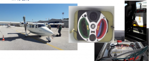
Flight planning: The geometric documentation of cultural heritage sites of such extent and morphological complexity as that of Meteora needs specialized techniques. The metric and imagery information has to be geometrically accurate and of high quality, resulting from economic, fast and automated methods. Techniques of aerial photogrammetry are recommended for mapping large and inaccessible areas with the above requirements. Within this project, conventional aerial images from manned or unmanned aerial vehicles are captured and airborne laser scanning is also implemented (airborne LiDAR – Light Detection And Ranging). 2220 vertical and oblique aerial images were captured by a manned aircraft, covering the entire site of Holy Meteora, i.e., an area of 10km2. A camera of type NIKON D800E with a lens corresponding to a focal length of 50 mm was used. Each image has a size of 7360 × 4912 pixels. The images were taken from a low altitude and correspond to an average scale of 1: 20,000. They were collected in July 2017. About 50 ground control points (GCPs) were collected through RTK GPS measurements for the scope of georeferencing. In order to capture the rocks Modi and Alyssos in greater detail, a Phantom IV RTK unmanned aerial vehicle (UAV) with a 20 MP camera was used and a total of 5000 vertical and oblique images were acquired. Special targets were placed on the ground for georeferencing purposes and their coordinates were determined using a dual-frequency GNSS receiver. Also, the coordinates of specific points on the rocks were determined by topographic measurements.
Planning of scans: LiDAR systems, provided by Geosystems Hellas S.A., were used for scanning the Archaeological Site of Meteora, where the rocks Modi and Alyssos are located. LiDAR is a remote sensing method that uses pulsed laser to generate altitude data in the form of point clouds. LiDAR systems are suitable for mapping areas with vegetation and for applications that require quick response. Before performing the laser scanning stage, it is necessary to determine the parameters that will ensure the acquisition of a dense point cloud with satisfactory accuracy. Within this project, the dual-channel airborne mapping system RIEGL VQ-1560i-DW was used. This system incorporates 2 band LiDAR sensors (one activated in near infrared and one in green) in the same cone, as well as two photogrammetric digital aerial cameras of type Phase One IXU-1000RS; one camera captures color aerial images and the other one captures infrared aerial images. The data collection was supported by a GNNS system and an inertial sensor of type Applanix AV-610. The flight planning had the following features:
- Simultaneous capturing of aerial images and LiDAR data
- Use of a LiDAR sensor activated in two areas of the spectrum at an angle to each other
- Use of a photogrammetrically calibrated camera and lens
- Minimum point density of the receiver: 40 (2×20) points per m2 on the ground.
- Ground sampling distance: 8 cm GSD RGB / NIR, scale 1/16000.
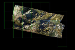
A total number of 23 high-resolution RGB aerial images were acquired in 2 flight strips (11 and 12 images), covering a total area of 3.82km2. Point clouds were also acquired for the same area. At the same time, 7 GCPs were measured in the field, well-distributed in the area covered by the aerial images and the point clouds by the RIEGL VQ-1560i-DW system.
Acquisition of terrestrial images: Terrestrial images were acquired, where it was deemed necessary, in order to capture some structural elements of the rocks (foundations, ruins, etc.) in greater detail.